- English HOME
- geography
- The Postcard Collection
The Postcard Collection
Please click here to enter The Postcard Collection Digital Database
The Postcard Collection Stored at the Department of Geography, Graduate School of Letters, Kyoto University
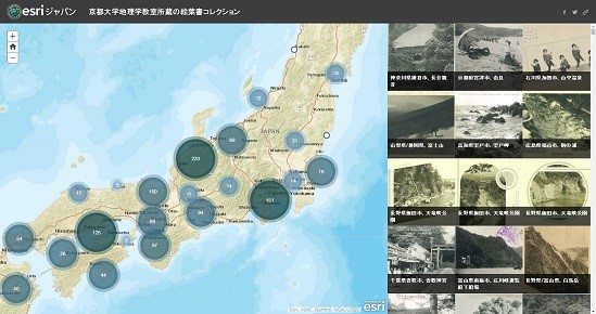
In January 2017, the Postcard Collection Digital Database of about 1500 postcards was released on the web site of Esri Japan. These postcards have been stored at the Department of Geography, Kyoto University for more than 80 years. Many of them are photos of well-known scenic and historic spots all over Japan in the early twentieth century. Some illustrate physical landscapes and local customs, while others show natural hazards such as volcanic eruptions. The collection includes a few postcards featuring overseas landscapes. These postcards are very valuable research materials for various academic disciplines, including geography, history, sociology, folklore, and tourism in modern Japan.
The envelopes for some of these postcards are stamped with the words “Geography-History Club, Kyoto First Middle School.” The Kyoto Prefectural First Middle School was the predecessor of the current Kyoto Prefectural Rakuhoku High School. On other postcards, students’ names, and in some cases their grades and classes, have been written in by hand. Among the hand-written characters, the words “the eleventh year of Showa reign” are discernable. This information indicates that some portion of the postcards stored at the Department of Geography were donated by the Geography-History Club, Kyoto First Middle School―or individually by club members― during the mid-1930s. Unfortunately, there is no record detailing how these postcards were collected. It would be an interesting future task to clarify the circumstances relating to how the Postcard Collection was acquired.
In the 2015 Spring Semester, our postcard project to build the digital database was started as a Small Group Seminar (Pocket Seminar) for first-year undergraduate students in all faculties. Professor Tanaka, who was in charge of this Seminar, set its theme as “Introduction to Regional Geography by Using Postcards.” Through photos and explanatory text on postcards, the ten students who took part in the course learned about local climates, historical backgrounds, industries, living styles, cultures, and changes in landscapes. They also tried to identify the locations where the photos were taken on a map, and took notes on bibliographical information. All of the postcard photos were digitized by scanning.
The most unique aspect of our database is that all of the digital images of the photos and their bibliographic information are identified on maps available on the site. Therefore, on this web site, the viewers can search for information related to each postcard interactively.
The purpose of releasing our postcard-image database is to allow the public, including researchers and students, to use the results obtained during the 2015 Pocket Seminar to conduct academic analyses or just out of intellectual curiosity about old postcards or modern Japan. The web application is provided by Esri Japan. Please note that there is an option to correct or add information in our database. Future improvements are expected through further research and information provided by our viewers.
The following people participated in this project: Kawaguchi Manuel, Tanaka Kenshiro, Ueda Yohei, Tamura Kosuke, Nakamura Fumihiko, Hamada Ayaka, Akatsuka Kohei, Ooi, Ryoya, Fujii Rei, Hikita Nami, Ito Reiko, Chen Lijun, Asakura Makito, Mikami Junko, Hoshida Yukihisa, and Natsume Muneyuki. I wish to extend my heartfelt thanks to them for their helpful cooperation.
January 2017
Tanaka Kazuko
Department of Geography
Graduate School of Letters
Kyoto University
Please click here to enter The Postcard Collection Digital Database


![Kyodai Ibunkai[in Japanese]](../../wp-content/themes/default/images/leftcolumn/bunner/ibun.gif)

![Gakuseishien Project [in Japanese]](../../wp-content/themes/default/images/leftcolumn/bunner/shien.gif)

![Kyoto Gakuha Archive (of Philosophy in Faculty of Letters, Kyoto University) [in Japanese]](../../wp-content/themes/default/images/leftcolumn/bunner/kyoto-gakuha.gif)

- About
- From Our Dean
- History
- Staff Only (in Japanese)
- Getting to Campus
- Contact
- Attached Facilities
- Library of Graduate School of Letters, Kyoto University
- Center for Studies of Cultural Heritage and Inter Humanities (CESCHI)
- Haneda Memorial Hall
- Center for Applied Philosophy & Ethics (CAPE)
- Asian Research Center for the Intimate and Public Spheres (ARCIP)
-
International Students
- Departments & Staff
-
Division of Philology and Literature
- Eastern
- Japanese Language and Literature
- Chinese Language and Literature
- History of Chinese philosophy
- Indological Studies
- Buddhist Studies
- Western
- Greek and Latin Classics
- Slavic Languages and Literatures
- German Language and Literature
- English/American Language and Literature
- French Language and Literature
- Italian Language and Literature
- Division of Behavioral Studies
- Division of Contemporary Culture
-
Division of the Joint Degree Master of Arts
- Affiliated Organizations
-
Kyodai Ibunkai
[in Japanese] - Projects for Education & Research
-
Gakuseishien Project
[in Japanese] - KYOTO UNIVERSITY ASIAN STUDIES UNIT
-
Kyoto Gakuha Archive (of Philosophy in Faculty of Letters, Kyoto University)
[in Japanese] - Projects completed
-
Kyoto Univ. -
Kyoto University CO-OP
[in Japanese]